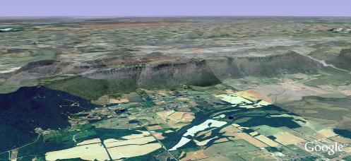
Green Mountain is located on the South East border of Huntsville, Alabama. It is a unique natural resource of great value to the community. It runs for seven miles along the Eastern flank of the City just north of the Tennessee River forming a beautiful natural backdrop to the city. The top of the mountain is a flat mesa surrounded by significant stone bluffs. The area atop the mountain is roughly 13.5 Sq. Miles. There are currently about two hundred and thirty homes on the mountain. More than a hundred lots are under development or for sale. The Mountain is special in a number of ways not the least of which is that it IS a mountain. It makes up a significant part of the southeast “view scape” of Huntsville. It remains largely undeveloped and thus represents a major preserve adjacent to the dense development of the City. Aside from it’s major scenic value it is an important watershed located between Aldridge Creek and the Flint River. It is an important buffer for Flora and Fauna. There are significant populations of deer, wildcat, fox, skunk, possums, raccoons, etc. and numerous bird species including the beautiful Pileated Wood Pecker. Not to mention the dubious honor of a “Bigfoot sighting”. It offers significant recreational value to the larger community focused on the Madison County Nature Trail. Those who live on the mountain are acutely aware of its unique value as a preserve and buffer and are committed to helping the larger Huntsville Community preserve this special place.
History
The following was written by long time Green Mountain resident Bill Varnedoe. We have included it without changes or editing as Bill invites because we think it just couldn’t be any better. Thanks. Bill!
WHAT I KNOW OF GREEN MOUNTAIN
by
W.W. Varnedoe, Jr.
Draft of February 25, 2002
This document will put in writing what I know or have heard about the mountain. If some author or historian knows more, has a correction, wishes to put it in more erudite English or to publish it be my guest, you have my permission. This is NOT copyrighted.
Please bear in mind, references to road names and numbers in this document are modern and are included only to give an idea of the referenced locations.
VERY EARLY HISTORY
An old Cherokee Land Boundary line crosses the southeast corner of the mountain, just below Rudolph Ruff’s house at 14201 S. Shawdee Rd. This was once the eastern boundary of Madison County.
Green Mountain is not named “green” because of its foliage as you might think, but is named after Charles D. Green, an early resident. Habitation of the mountain, beyond that of a very few, is recent from an historic Huntsvifle viewpoint. Parts of the mountain were obtained from the government as early as 1838, but most was claimed in the 1850’s. Some parts were not obtained until as late as the turn of the century. For instance, my land on North Shawdee was not granted by the U.S. Government until 17 March 1899 to James Limerick. At that time, our mountain had no name of its own. Maps of the 19th century call all of the chain of mountains to the east of Huntsville, “Monte Sano.” This includes: Chapman Mt., Monte Sano, Huntsville Mt., Green Mt. and Wallace Mt. Our Mr. Charles Green was actually born Kurt Gruene on 6 October 1830 in Denmark. He became an American citizen in 1846, moved about a bit, and was on his way from Harris Co. GA to Texas when he passed through Huntsville in 1860. He stopped here as his wife, Martha Catherine (Craig) Green, was pregnant. She died in 1863 and in 1865 he married Mary Elizabeth Pike. He bought 120 acres on S. Shawdee, just north of the power lines, mostly in what is now the Nature Trail Park, from a Mr. Grimwood in 1869. He bought an additional 20 acres south of the power line in 1877, which included Alum Cave. He owned more land in town and elsewhere, but he lived on the mountain and gave it his name. The 1900 census lists him as a cabinet maker by profession. He died 9 October 1902 and is buried in Maple Hill Cemetery. He had 15 children: Kate(1861), Charles(1867), Bernice(1869), Eddy(1871), Albert(1873), Emma(1875), Cornelia T.(1876), Abnes(1878), Laton(1880), Earnest(1882), Anna S.(1884), John P.(1885), Mary E.(1888), Henry L.(1890) and William L.(1893). All of them but one either died or later moved to Texas. Charles Campbell, the husband of Mary E. Green who was born on the mountain 3 December 1888, and was still alive in Huntsville as late as 1977.
Other early landowners, obtaining land from the government, were John Franklin, William E. Draper, Joseph A. Brown, Asa Sheldon (in 1838, earliest owner of Russell Point), John W. Ellett (owned most land), Isaac S. Ellett, Val Morgan and Alexander Dean (The land at the bend of Riverview). We do not know if these people just owned the land or if they lived up here. No Indians lived up here that we know of, mainly due to the lack of water and access. However, both the Cherokees and Creeks hunted and camped here. Bob Saidla has a fine collection of Indian flint points, some of which he found on the mountain.
An old log cabin used to be located just east of Village Square and south of Valley Green. It had a dug well which was still there in the underbrush and blackberry bushes for a long time. (This cabin was burned by the Green Mt. Vol. Fire Dept. as a training exercise in 1968.) An old chair factory and/or a tannery was rumored to be somewhere along Valley Green or Village Square behind the Nature Trail Park, on the old Franklin’s place, or in this general area. This fits with Mr. Green’s occupation as a cabinetmaker.
Perhaps it was he. Cockfights were held on south Riverview (now Monte Vedra) as late as after World War II which helped contribute to the mountain’s reputation as a wild place.
Surveys of 1947 mention the “Rock” corner and the “Metz” corner, apparently somewhere along N. Shawdee.
MORE RECENT HISTORY
Julian Hamilton and Bill Varnedoe (the author) walked what would become the Space Walk Trail from Monte Sano to Green Mountain in the 1950’s and liked this mountain so much that we and our friend, Bob Moore, bought land here and moved up, I, in 1956. My very good friend, Leo Wilson, who had already moved up, also influenced me and so I bought my land next to his. Leo and I had known each other in Florida before either of us moved to Huntsville.
In the 1950’s when Redstone Arsenal was first firing up as a missile development center, American Machine and Foundry Co. began to buy up the mountain. Their plan was to quarry out the inside, sell the rock, then make the hollow mountain into an underground missile plant. Although they and the city Chamber of Commerce used “strong-arm” tactics to get mountain residents to sell, a few people held out and refused. Two of these were the Hamiltons and the Moores, (each with 40 acres at about 13,300 Shawdee.) Some of those who left at this time, moved to Keel Mt. Of course, the dream of the underground factory never came about and AMF sold their entire holdings to a group consisting principally of Buck Creek Industries and Lane Realty Co. It was they who originally laid out Monte Vedra Subdivision and installed a water system using a tank just NW of Valley Green and Village Square. After rough cutting the main streets and blacktopping part of Monte Vedra, they never went further and most of this development fell into ruin. They eventually sold everything to Clara Payne. The city had the old water system refurbished, which had also fallen into disrepair, and integrated it into the new mountain-wide system. The old tank (which was never used) was abandoned in lieu of the present high tank on Riverview. Monte Vedra, Valley Green and Village Square were paved by the county in return for a donation of land that became the Nature Trail Park. The Paynes went bankrupt and all of their land was sold off at auction in 1994 (?) to various buyers.
The mountain became part of the city in 1975 at the request of the residents. This came about because of school desegregation. Up to now the mountain kids went to Huntsville schools. At that time adherence to school boundaries became very strict due to the desegregation efforts. This forced the mountain kids to go by bus to New Hope, the nearest county school. The bus would go down Green Mountain road into the city, pass right in front of Mountain Gap School and Farley School, around Hobbs Island to New Hope. (South Green Mt. Rd. did not exist.) Getting the mountain into the city relieved this awkward situation. Many residents opposed annexation, yet a 2/3 majority wanted relief. The residents agreed not to press, or even ask, for city services in return for Huntsville backing the annexation petition. But this “gentleman’s agreement” also caused the city to be slow in giving the mountain full city services. Although there has been a complete turnover of personnel of both the city government and mountain residents, and few, if any, remember the “agreement,” services are still slow in materializing. We seem unable to get the city to build a firehouse, for instance.
The Sloans once had a house located right at the top, at the intersection of Green Mountain Rd. and Shawdee, at the location of the present Bell Telephone tower. It was moved, whole, to 13,010 S. Shawdee about 1960 and considerably remodeled. It is still there.
Stanley Owens had a house, the remnants of which can still be found, at about 12,100 N. Shawdee. He moved to a new house at 5030 Willow Dr. and later moved down off the mountain. His son now lives on Willow Dr.
There is a story about the location of N. Shawdee. And about the Owens versus the Tuckers, who lived across Shawdee from Stanley Owens. One day Stan got up to discover Tuck plowing up his front yard for a garden. The dispute concerned the property line. Owens produced a document, signed on 19 April 1947 by the residents, agreeing to use the street as the property line. Tucker, however, claimed the street was mislocated and the line lay 50 feet west of the street. (Tucker was correct. The sharp corner at the Telephone Tower is on the line, but the N. Shawdee road angles off to the east and the 1/4 section line misses the corner of Montcrest, Willow and N. Shawdee, off to the west.) The dispute went to court, and the final ruling was that since the wives had not signed the agreement, the document was invalid. The 1/4 section line is the property line, not the street. The telephone line runs along this property line through the woods.
Telephones came to the mountain in the 1960’s, at first, only as 4 party lines. In the pre-city days, before county-wide garbage collection, a dumpster which was emptied weekly by the county was located on Recreation Point road. Residents took their garbage there.
The Green Mountain Civic League was informally organized in the 1960’s with Stanley Owens as President. It lapsed into inactivity, until it was reactivated and given a formal constitution in 1985 with Mike Pitruzzello as President. In 1993, it was again reorganized with new Articles of Corporation and By-Laws.
A community watch program was instituted in 1990, with Norma Oberlies as Captain. Forest and Janice Martin are now in charge. One of the main things the Community Watch had to contend with in the old days were late night teen age parties. These drunken brawls were noisy and often set the woods on fire. These incidents also contributed to the mountains unsavory reputation. The development of Monte Vedra and the persistent work of the Community Watch has virtually eliminated this nuisance.
At one time a property owner at the south end at the foot of the mountain sold an option to Vulcan Materials to quarry the south end of the mountain for Limestone. This would have been a disaster for the mountain. Besides the noise and danger of the blasting, the natural beauty would have been destroyed. Just look at the eyesore quarry at the north end of town the seems to be removing the entire mountain., And listen to the complaints of those nearby residents. A campaign led by our Civic League helped other landowners in that area as well as mountain residents petition to bring that area into the city. This action defeated that threat to our tranquility, as the city would not grant the necessary license to quarry.
Another controversy that has split the opinions of the mountain residents was the plan Huntsville developed to build greenways in the city. Aldridge Creek Greenway is an example that has been a great success. The plan was to place a path along either the top ridge or a bench below the top of the mountains, all the way from Monte Sano to the Tennessee River. However a large contingent of residents did not want a trail below their property, Others wanted this land to become Land Trust property. The argument of the cons believed this would introduce undesirable traffic and possible thieves. The pros, however, believed it would enhance our property and neighborhood. They cited the lack of trouble by residents along Panorama Drive on Monte Sano, where such a trail has existed below their bluff for many years. It IS hard to see how a hiker would climb a cliff, steal anything, and exit on foot. We prefer to have a rustic trail below us to having housing developments climb up to our property. But the cons remain adamant. While many of us still would like to see hiking trails around the mountain. To avoid entering into this difference of opinion, the city put the Space Walk Trail portion of the Master Greenway Plan on hold, where it languishes today, although some portions have recently been acquired by the Land Trust. They now own portions of Sugartree Trail and large tracts below Riverview (below the bend and at Valley Green.)
GREEN MOUNTAIN VOLUNTEER FIRE DEPARTMENT
The Green Mountain Volunteer Fire Department was organized in 1965. We only had some hand pumps and fire rakes which we carried in our private vehicles. Soon we bought an old fuel tanker truck, to which we added a fire pump. Chief Tolen of the Huntsville Fire Dept. often lent us a city truck when ours was out for repair. Later, the city left a reserve truck stationed on the mountain for us to use. Now, they assign a fully equipped truck here for our use. In addition they have integrated us into their radio alerting and communication system. In 1975, our volunteers took the same qualification course city firefighters took and became State Certified. All of our active firefighters, including several women, are State Certified. When we started, there were no water mains; that old tanker was our water for firefighting back then. Water mains came later. We now, of course, have not only a fine first line pumper but also an excellent brush truck and a rescue vehicle. The mountain’s ISO (insurance) rating went from 10 (no fire dept.) to 9AA, (the best possible without water mains) then, after the water mains were added, it was rated a 3, the same as the rest of Huntsville. The Green Mt. VFD is a charter member of the Madison Co. Association of VFD’s. In addition to fires and other medical emergencies, the fire dept. has been active in several rescues of people fallen off of our bluffs. To date, there have been 3 fatalities and 5 successful evacuations. Most (not all) were caused by alcohol and/or drugs, which certainly don’t belong next to a cliff!
ROADS
The earliest map of the area of Green Mountain is a map of Madison County made in 1818. There are few details. The Tenn. River, the Flint River, Aidridge Creek and the Cherokee Land Boundary are shown so that the approximate location of the mountain can be estimated. That Cherokee land boundary which was the eastern boundary of Madison County in 1818, passes over the south end of the mountain just below Rudolph Ruff’s house at 14,201 S. Shawdee. A county map of 1850 shows no roads up on the mountain, but it does show the Blevins Gap road and the Phillips Gap road. The gap between Green Mt. and Wallace Mt. to the south is now called Lee Gap but earlier it was called Phillips Gap and a road, Phillips Gap Rd. ran over it to connect Farley and Owens Cross Roads. In times past, a road also crossed over Blevins Gap, the gap between Green Mt. and Huntsville Mt. (The new Four Mile Post Rd. does not follow its path.) A county map of 1875 has no roads up the mountain, but shows both Blevins Gap Rd. and Phillips Gap road. The county map of 1921 shows that the Blevins Gap road had disappeared but the Phillips Gap road was still there, and there were still no roads, recognized by the county, up the mountain. By 1948, the Phillips Gap road had vanished, but the mountain was still blank on the county road map. Only traces of these abandoned roads can be seen today.
Of course, Green Mountain Road was originally just an unmaintained wagon road. It was later widened for autos and graded, well, sort of, when the county accepted it as a county road sometime between 1948 and 1952. Then it was graveled. Finally in the early 1950’s it was blacktopped, not all of it, just the part going up the mountain and none of the roads on top. You see, a county commissioner was not friendly with a Mr. Taylor, who had a farm at the foot of the mountain, so the leg across the flats to Todd Mill Rd. was left dirt, not even graveled, for some time. Some of us remember getting stuck in the mud on that part of Green Mt. Rd. (Bailey Cove Rd. and Camelot subdivision did not exist.) At first, only the road up the mountain was blacktopped; roads on top were still gravel. North and South Shawdee and part of Riverview were blacktop by 1965; asphalt pavement came later. But in all of this, the original grade of the mountain road was not changed. It is still just a glorified wagon road! One old road from the top of the mountain ran at an angle, from about 5008 Riverview to about the location of Valley Green and Village Square. Traces are still visible between Riverview and Valley Green, where not destroyed by development.
South Green Mountain Rd. (the “Back Road” to Owens Cross Roads) was not opened until the late 1980’s. A sort of logging road was there, passable only to four wheel drive vehicles (and some fools who tried it in ordinary cars, like I once did.)
Most present road names were selected by a mountain residents committee, headed by Francis Moore, in the 1950’s.We named most of the following roads:
Shawdee sounds like an American Indian name. We residents knew that a “Shawdee” family lived in early Huntsville, and choose this name for the principal road. Later research, however, has disclosed that the family was not Indian at all, but French! The proper spelling of the name was Schaudis. But by then, spelling for the road had been locked in and printed on County maps as Shawdee. Mr. Schaudis who is probably turning over in his grave at the present spelling, had a shoe store on the square downtown.
The name for Riverview is obvious, but it originally kept going past the present Valley Green Rd. to approximately 14,000 Monte Vedra, along the bluff. At its end was what we called “the Rock House,” located about at the east end of the cleared space north of 14,001 Monte Vedra Dr. Another house stood on the east side of Riverview at about 13,024 Monte Vedra where Peter Pryor’s house is today. It was occupied by the Helms family. Unlike Monte Vedra, Riverview ran next to the bluff. The Helms place was on the east side of the road. Francis Saidla was a Helms before she married Bob, and she was born while her family lived there. She is a true Green Mt. native. The Saidlas now live on the mountain at 12,004 Willow Cir.,Montcrest just sounded good as a street name., Green Oakes was named after Bobby Oakes who lived on it, so was Carr Lane after Mrs. Carr, Sloan Rd after the Sloans. and, recently, Arlon Owens Cir., Willow Rd. was named after the Wilsons and Owens, the only two families that lived on it then. Dale Rd. was named after Dale Cruse. Wade Point Rd. was so named as the road that ran to Wade Point. It still does. Ketova Way is made from ~r ]~mas \~rnedoe, my son. Village Square, Valley Green, Monte Vedra and Mason Blanche were names put on the plat of Monte Vedra Subdivision by Lane Realty, when they laid it out. Sunset Bluff is a platted name. Recreation Point Rd., a private road, runs to Recreation Point, a favorite old picnic spot. This road was put in by NASA when they had a tracking station near the point. It was later abandoned and the facility completely removed.
CLIMATE
It nearly always averages about 4 degrees cooler on the mountain than in town, making the summers more pleasant. But then our winters are more severe. In the 1960’s we had 18 inches of snow, followed by a low of minus 18 degrees Fahrenheit. But we had fun, adults as well as kids. Once in the ‘60’s the lake at North Shawdee and Montcrest froze thick enough that a car drove across. That was the day we had an all-day ice hockey game. We didn’t have skates or correct sticks, but we just slid about on boots with tree limbs for hockey sticks. The puck was a dented tin can. The teams were of indefinite size and the composition changed as people came and went! This lake, Muzon Lake, was called the Johnson Pond in 1947.
During one of those big snows, while no one could use the road up the mountain because it was impassable, we sledded on it. Charlie Loveday went all the way to the bottom and on to the bridge! A big ice storm once had the mountain without power for a week. The National Guard brought up their portable generator and, by turns, let people use it long enough to lay in a supply of water. Remember, we were all on deep wells then, as we had no water mains, and depended on electricity to pump our water.
GEOLOGY
The geology of the mountain is relatively simple. Green Mountain is an isolated fragment of the Cumberland Plateau. The valley lies at about 600 feet above sea level while the mountain averages 1200 feet, for a height of 600 feet above the valley. The bulk of the mountain is flat bedded limestone of Mississippian age (about 300 million years old.) There is a very thin layer of coal between this and the Sandstone caprock of Pennsylvanian age. This Sandstone forms our bluffs that ring the mountain. These cliffs average about 20 to 30 feet high, and in isolated spots reach 70 feet. From the top down the layers are: Pottsville Sandstone), (cliffs); Pennington Formation (the bench) a thin layered limestone; Bangor Limestone, thick betted; Hartselle Sandstone (nose of protrusions on the west, not present everywhere; Monteagle Limestone, the lowest layers of the mountain.
Although the layers of all these rocks are essentially flat and almost level (they slope to the SSE at about 50 feet per mile,) there are local minor waves and irregularities. A slight “syncline” or trough runs N to S along the axis of the mountain and accounts for what water exists in the wells since the water is held by the layers of rock being slightly tilted up to each side, sort of saucer shaped. That is why water drains to the middle of the mountain into the Nature Trail Lake and off down Alum Cave Hollow. Alum Cave, by the way, is not a “real” cave but simply a bluff overhang. The mountain, being limestone, there are plenty of true caves, however, many have vertical pit entrances and should not be entered without extensive training. Dye placed in the stream from the Nature Trail Park, whose stream sinks into Green Grotto, about halfway down the mountain, emerged at White Spring near the old boat harbor at Hobbs Island.
Water and wells on the mountain were a hit or miss proposition. The very old residents had dug shallow wells, which would go dry. By the 1950’s all of the usable wells were drilled and at least over 100 feet deep. Many were quite marginal; some people had two wells and switched between them, while others were very good. I, myself, had a good one, and I had it connected to my kitchen cold water until recently, since it tasted better than city water.
WILDLIFE
Deer are still resident and occasionally they can still be seen crossing the roads. I have seen Foxes, Squirrels, Coons, Chipmunks, Ground Hogs, Skunks and Beaver as well as Snakes and other wildlife on the mountain. Hawks can be seen riding the thermals along the Narrows. Coyotes and wildcats have also been reported.